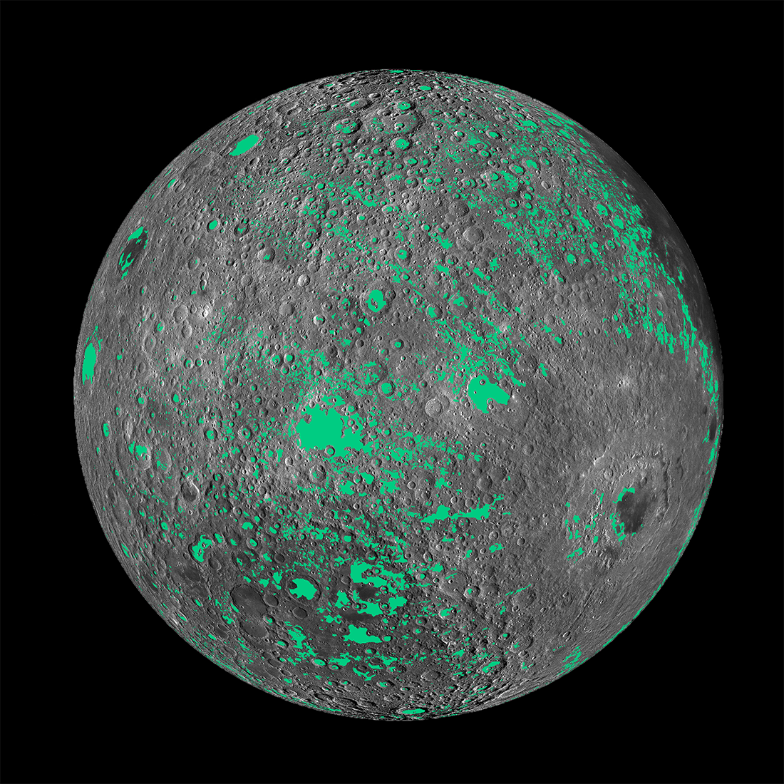
The image at the top of this post is a frame captured from the video below, which displays the first globally consistent map of light plains on the Moon. Light plains are shown in green.
What are light plains? They are smooth, flat, maria-like deposits that are higher in albedo (reflectance) than the smooth, flat, dark maria. Light plains cover about 9.5% of the lunar surface, while the maria cover about 16%.
Before the Apollo 16 mission in April 1972, light plains were thought to be mostly volcanic in origin. Apollo 16 astronauts John Young and Charles Duke landed their Lunar Module on the light plains Cayley Formation at a landing site named Descartes (-8.97º lat, 15.5º lon). They expected to sample ancient lunar volcanic rocks, but found instead breccias (rocks made up of rock fragments cemented together). Scientists back on Earth identified nearly all of the 96 kilograms of lunar surface samples Young and Duke collected as ejecta blasted across the lunar surface by the giant impact that formed the Imbrium Basin.
Since Apollo 16, most light plains have been interpreted as largely impact-related in origin, but the exact mechanisms of formation and modes of emplacement remain unclear. That's where today’s video comes in.
LROC scientist Dr. Heather Meyer, a Postdoctoral Researcher at the Lunar and Planetary Institute, mapped the light plains all over the Moon using image data from the LROC Wide Angle Camera (WAC). To make the map, she employed two LROC WAC lunar global image mosaics with opposite lighting conditions. This meant that most shadows cast by lunar surface features were eliminated. She then used a roughness map based on LROC WAC topography data to locate flat areas. Finally, flat, smooth light plains were distinguished from flat, smooth maria by using a global maria map.
Of particular note on the global light plains map are ray-like clusters of light plains extending outward from the Orientale Basin (-19º lat, -94º lon), at about 3.8 billion years old the youngest of the great lunar impact basins. The pattern of light plains observed outside Orientale confirms some of the interpretations based on Apollo 16 analyses and other past work: large basin formation did in fact contribute significantly to the population of light plains. Although not all light plains are related to basin formation, the light plains outside the Orientale Basin are telling us something fundamental about the way basin-scale impacts modify the lunar surface and to what extent.
The Orientale basin-forming impact modified the lunar surface nearly 2,000 km from the basin's rim! If all basins had comparable effects on the lunar surface, then the largest lunar basin – the South Pole-Aitken Basin, which dominates the Moon's farside hemisphere - must have modified almost the entire lunar surface.
Extending examination of lunar surface modification beyond the ejecta deposits surrounding large basins provides a larger area to reference when seeking relationships between large basins and surrounding deposits. This provides scientists with new opportunities to understand lunar stratigraphy, which forms the basis of the lunar geologic timescale from which lunar history is interpreted.
Interestingly, previously unidentified flow features were found among many light plains deposits during the creation of the global map. This is critical because flow features preserve information about the emplacement dynamics and physical characteristics of the materials making up light plains. By studying these flow features, we can determine whether the light plains are formed by dry debris, a significant melt component, or perhaps some combination of the two.
Are you interested in learning more about the lunar light plains and the new light plains global map? Check out the following resources.
Related Featured Images
Out of the Shadows: Impact Melt Flow at Byrgius A Crater
Published by David Portree on 20 April 2018