Today is the fifty-first anniversary of the Apollo 12 Moon landing. Similar to Apollo 11, many of the goals of this second lunar landing were engineering in nature. However, Apollo 12 astronauts spent three times longer exploring the Moon (a total of about 7.5 hours vs. 2.5 hours), thus having the opportunity to address more science goals.
Apollo 11 proved to be a great success – the United States landed a man on the Moon and returned him safely to the Earth. At this point President Kennedy's challenge had been met, and NASA could get on with the business of exploring the Moon. Next up was honing the Lunar Module's (LM) ability to make a pinpoint landing, which had proved difficult for Apollo 11. Many of the future landing sites were in areas with rough terrain, meaning that the LM would have to come in steeply and set down within a few hundred meters of a designated point to achieve future mission objectives. The conservative engineering and safety constraints imposed on Apollo 11 were still in effect for the Apollo 12 landing, dictating an equatorial site on a flat mare surface.
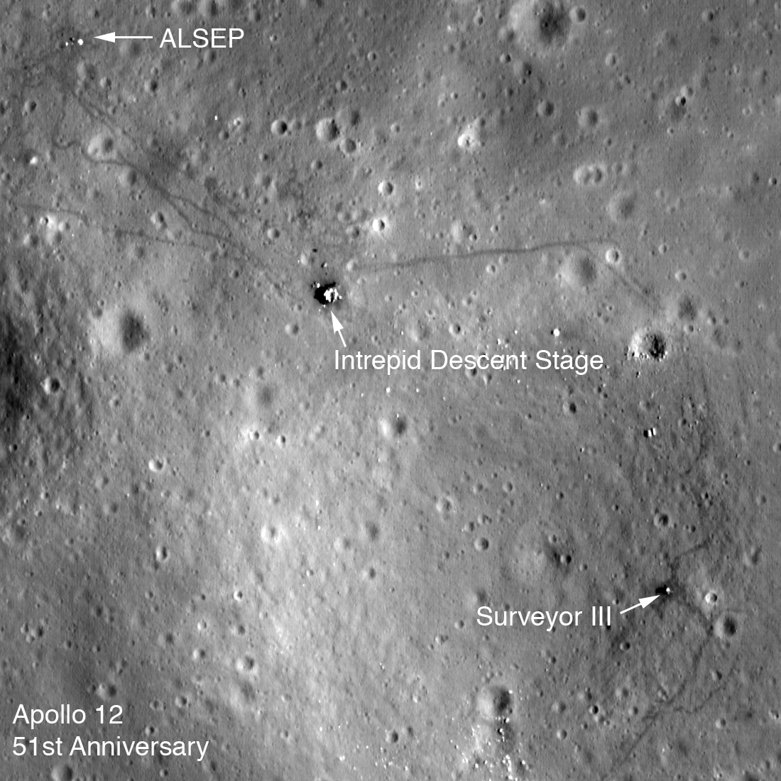
Within those constraints, the Surveyor III landing site in western Oceanus Procellarum (3.0162°S latitude, 336.5820°W longitude, -1433 meters elevation) was selected for Apollo 12. Of course, landing within walking distance of the now still robotic lander (operated from 20 April 1967 to 3 May 1967) would prove the pinpoint landing capability and allow the astronauts to return parts from the Surveyor to see how they had fared during their time on the Moon. The Surveyor 3 site also provided the opportunity to sample distal ejecta within a ray extending from Copernicus crater (over 300 km away), and what appeared from crater counts to be relatively young mare basalt.
Pete Conrad (Commander) and Alan Bean (LM Pilot) piloted Intrepid to a landing within 200 meters of Surveyor III on 19 November 1969. During their brief stay of thirty-one and a half hours, the two astronauts performed two extra-vehicular activities (EVAs), each a little under four hours in length. The LROC team animated the two traverses based on Apollo transcripts and photographs, with a NAC image as the basemap. Enjoy!
Also - be sure and visit the LROC Apollo 12 Temporal Traverse Map!
Related Featured Images:
First Look: Apollo 12 and Surveyor III
Apollo 12 Second Look: Midday on the Ocean of Storms
Surveyor Crater, Before and After
Published by Mark Robinson on 13 November 2020