Today is the fiftieth anniversary of the Apollo 14 Moon landing. Unlike Apollo 11 and 12, which focused on engineering goals such as landing precisely on the Moon, Apollo 14 focused on addressing science goals. Antares (lunar module) landed in the Fra Mauro highlands, the original destination of the failed Apollo 13 mission, essentially taking on that mission's objectives. This was the first crewed landing in the lunar highlands and not in the mare.
The Apollo 14 astronauts who landed on the Moon, Alan Shepard (Commander) and Edgar Mitchell (Lunar Module Pilot), completed two extra-vehicular activities (EVAs) while on the surface. They spent a total of 9 hours and 22 minutes setting up equipment, taking photographs, collecting samples, and exploring.
During the first EVA the astronauts primarily focused on setting up many different pieces of equipment, including the Apollo Lunar Surface Experiments Package (ALSEP), the Lunar Ranging Retroreflector (LRRR), and the Lunar Portable Magnetometer (LPM). You can see these pieces of equipment not far from the Lunar Module (LM) in LROC NAC images of the landing site. To conduct the Active Seismic Experiment (ASE; part of the ALSEP), the astronauts deployed three geophones and thumpers (explosives to generate seismic waves). When the spacecraft and the Sun are both in the right position, we can see the geophone lines in the NAC images as well! Shepard and Mitchell also took photos and collected samples as they made their way back to the LM.
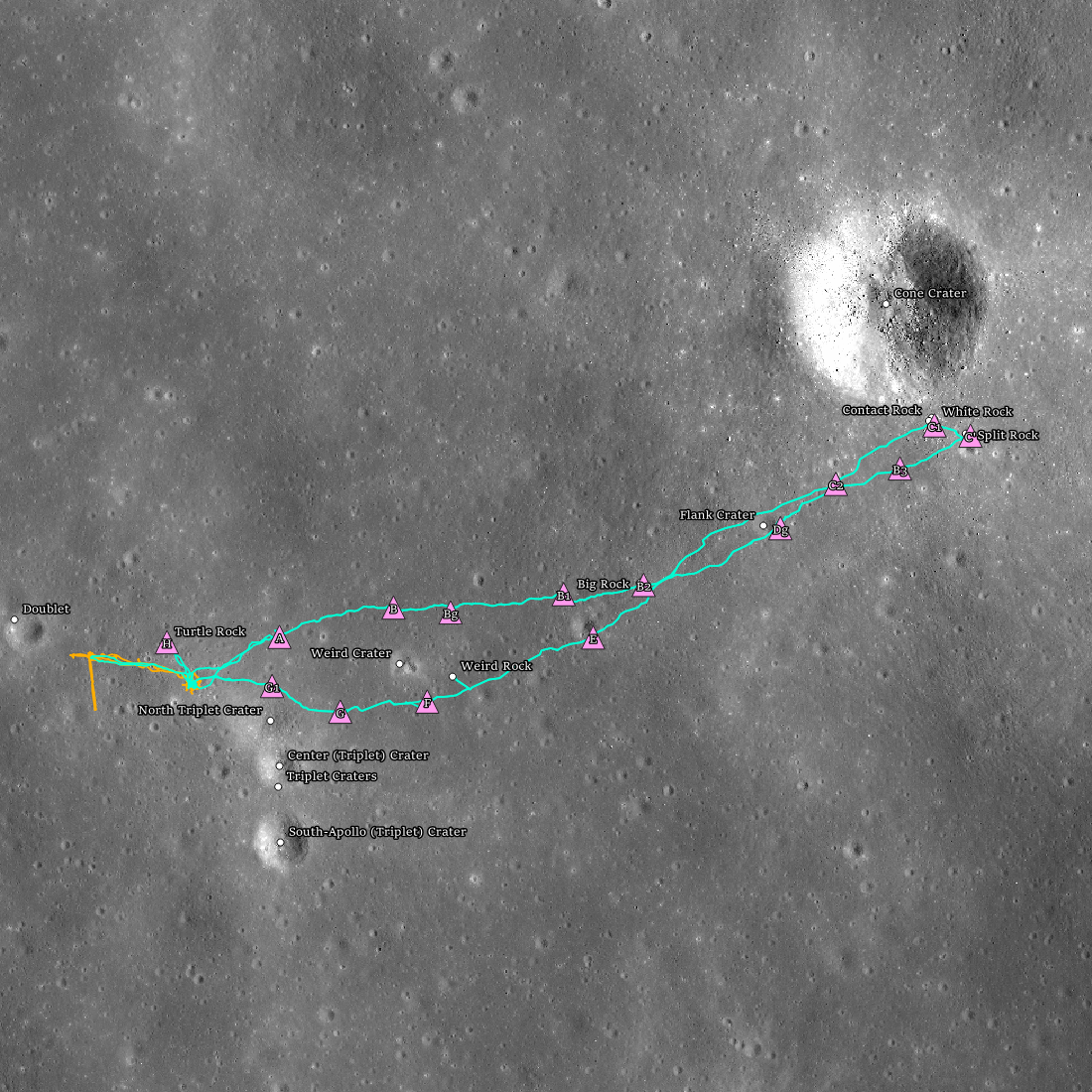
The second EVA was dedicated to traversing up to the rim of Cone Crater, collecting samples of ejecta along the way. The ejecta farthest from the crater rim originated from close to the surface, while ejecta close to the crater rim comes from the deepest parts of the crater. By picking up samples at regular intervals as they approached the rim, the astronauts could create a collection that represented the stratigraphy of the landing site. However, they did not quite make it to the rim. The undulating terrain made it difficult to determine where they were, and depletion of oxygen and water from covering so much ground in their bulky suits made them turn back before reaching their destination. But how close were they to the rim? Tantalizingly close! Their final stop at Saddle rock was only about 30 meters from the rim.
They pulled along the Modular Equipment Transport (MET), a kind of wheeled handcart that carried their tools and samples. This was the first (and only!) time the MET was used. The difficulty in covering so much ground while carting tools and samples showed the need for lunar rovers on future missions (Apollo 15, 16, and 17). Despite these challenges, they did accomplish their goal of collecting the radial sample profile along the flank of Cone crater and returning very valuable rocks from which much was learned about the Moon.

The LROC team documented the astronaut activities on a minute-by-minute basis to help celebrate this wonderful moment in history. We've carefully mapped two EVAs based on Apollo 14 transcripts, photographs, and results from the Passive Seismic Experiment (PSE; also, part of the ALSEP). Head over and explore these temporal traverse maps, which use a NAC image as the basemap to show the astronauts as they progressed minute by minute through both EVAs, across all the stations where they stopped to collect samples, take photographs, and set up experiment hardware. — and remember to view the Apollo 14 landing site in 3D using Lunar QuickMap!
Check out the other temporal traverses here:
Read more about Apollo 14 in these related posts:
Precise 3D Measurements of Objects at Apollo 14 Landing Site from LROC NAC Stereo Images
Trail of Discovery at Fra Mauro
LROC's First Look at the Apollo Landing Sites
Published by Megan Henriksen on 5 February 2021