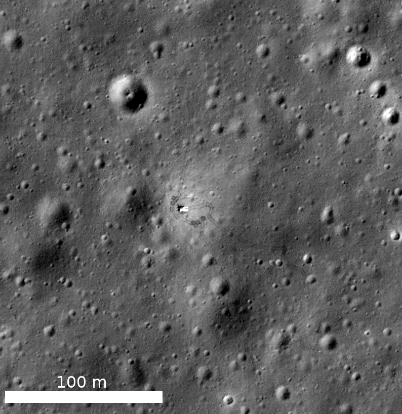
The LROC team recently completed a large effort updating coordinates of known robotic and crewed targets on the Moon (landers, rovers, equipment, and impact craters). Using multiple images of each site acquired between 2009 and 2015, an improved LRO spacecraft ephemeris, and a temperature-dependent camera orientation model, the LROC team derived accurate coordinates for each soft-landed spacecraft, rover, and spacecraft impact crater that we have so far identified. Details of how these coordinates were derived were just published in the journal Icarus by Wagner and co-workers.
Making sure that the lunar cartographic network is accurate is a critical component for planning future lunar missions for both human and robotic exploration of the Moon. The historic spacecraft serve as benchmarks (especially the laser retroreflectors) for global mapping efforts. When new images of each site arrive, and the final ephemeris is in hand, we can check if the hardware has "moved" – well, actually we see the level of uncertainty in computing latitude/longitude coordinates which is currently about ±15 meters.
The table at the bottom of this post lists the final coordinates (mean Earth/polar axis (ME) system) of all spacecraft hardware and spacecraft impact craters. You can also download a PDF version of this listing and an Excel spreadsheet containing coordinates for each image at each site.
Check out this map of robotic spacecraft sites on the lunar surface!
To generate the list of observed latitudes and longitudes, we compiled a list of line and sample coordinates for the center of each object in each image. Each image was then initialized using the USGS Integrated Software for Imagers and Spectrometers (ISIS) software package, attaching the appropriate spacecraft position and pointing information, along with the GLD100 lunar shape model for elevation. ISIS routines were then used to compute the latitude and longitude of the spacecraft (or crater) in that image. The LRO spacecraft position was provided by the latest cross-over corrected spacecraft positioning kernels provided by the LRO LOLA team, with an orbital position uncertainty of ±15 m. Finally, temperature-corrected NAC camera kernels produced by the LROC team contributed to the high precision and accuracy. The coordinates listed in the table are the statistical means from multiple images acquired for a particular site.
Crewed Missions
| Object | Mean Observed Lat | Mean Observed Lon | Elevation (m) | Uncertainty (m) |
| Apollo 11 LM | 0.67416 | 23.47314 | -1926 | 0.3 |
| Apollo 11 PSE | 0.67322 | 23.47315 | -1928 | 0.4 |
| Apollo 12 LM | -3.0128 | 336.5781 | -1422 | 2.2 |
| Apollo 12 ALSEP | -3.0098 | 336.5751 | -1422 | 2.2 |
| Apollo 12 PSE | -3.0099 | 336.5752 | -1423 | 2.6 |
| Apollo 14 LM | -3.64589 | 342.52806 | -1062 | 0.4 |
| Apollo 14 ALSEP | -3.64419 | 342.52232 | -1064 | 0.4 |
| Apollo 14 PSE | -3.64408 | 342.52233 | -1064 | 0.4 |
| Apollo 15 LM | 26.13239 | 3.63330 | -1931 | 1.0 |
| Apollo 15 ALSEP | 26.13406 | 3.62991 | -1924 | 0.5 |
| Apollo 15 PSE | 26.13411 | 3.62980 | -1924 | 0.3 |
| Apollo 15 LRV | 26.13174 | 3.63803 | -1928 | 0.5 |
| Apollo 16 LM | -8.9734 | 15.5011 | 8 | 3.0 |
| Apollo 16 ALSEP | -8.9759 | 15.4986 | 12 | 3.0 |
| Apollo 16 PSE | -8.9759 | 15.4986 | 12 | 2.5 |
| Apollo 16 LRV | -8.9729 | 15.5037 | 10 | 3.7 |
| Apollo 17 LM | 20.1911 | 30.7723 | -2626 | 3.5 |
| Apollo 17 ALSEP | 20.1923 | 30.7655 | -2622 | 3.5 |
| Apollo 17 LRV | 20.1896 | 30.7769 | -2628 | 3.2 |
| Apollo 17 SEP | 20.1920 | 30.7768 | -2627 | 3.7 |
Robotic Missions
| Object | Mean Observed Lat | Mean Observed Lon | Elevation (m) | Uncertainty (m) |
| Surveyor 1 | -2.4745 | 316.6602 | -1889 | 5.6 |
| Surveyor 3 | -3.0162 | 336.5820 | -1433 | 2.6 |
| Surveyor 5 | 1.4551 | 23.1943 | -2052 | 11.9 |
| Surveyor 6 | 0.4742 | 358.5725 | -757 | 6.7 |
| Surveyor 7 | -40.9812 | 348.4873 | 81 | 3.5 |
| Luna 16 | -0.5137 | 56.3638 | -2452 | 3.7 |
| Luna 17 | 38.23764 | 324.99837 | -2471 | 0.5 |
| Lunokhod 1 | 38.3150 | 324.9919 | -2471 | 3.8 |
| Luna 20 | 3.7863 | 56.6242 | -1780 | 4.3 |
| Luna 21 | 25.9994 | 30.4076 | -2680 | 13.4 |
| Lunokhod 2 | 25.8323 | 30.9222 | -2761 | 7.5 |
| Luna 23 | 12.6667 | 62.1511 | -3668 | 3.0 |
| Luna 24 | 12.7142 | 62.2129 | -3670 | 3.7 |
| Chang'e 3 | 44.1214 | 340.4883 | -2630 | 9.1 |
| Yutu Rover | 44.1208 | 340.4878 | -2630 | 12.9 |
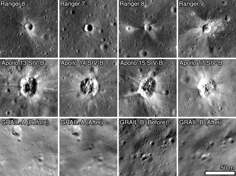
| Ranger 6 | 9.3864 | 21.4806 | -1996 | 4.4 |
| Ranger 7 | -10.6340 | 339.3230 | -1791 | 6.4 |
| Ranger 8 | 2.6376 | 24.7881 | -2165 | 4.9 |
| Ranger 9 | -12.8281 | 357.6116 | -1531 | 5.8 |
| A13 SIVB | -2.5550 | 332.1125 | -1166 | 9.8 |
| A14 SIVB | -8.1810 | 333.9695 | -1785 | 4.5 |
| A15 SIVB | -1.2897 | 348.1755 | -1109 | 3.8 |
| A16 SIVB | 1.9210 | 335.3770 | -1104 | 19.2 |
| A17 SIVB | -4.1681 | 347.6693 | -1206 | 5.6 |
| GRAIL-A | 75.6088 | 333.4060 | 750 | 10.7 |
| GRAIL-B | 75.6508 | 333.1659 | 1039 | 12.2 |
| LADEE | 11.8494 | 266.7506 | 2803 | 6.1 |
Link to journal paper:
Related Featured Images
Surveyor 7 - America's Last Lunar Unmanned Lander
Surveyor Crater - Before and After
Mare Crisium: Failure then Success
Surveyor 1 - America's first soft lunar landing
Rocket Impacts recorded by the Apollo seismic network
Published by Mark Robinson on 25 November 2016