Permanently shadowed regions, or PSRs, are areas near the north and south poles of the Moon that never receive direct sunlight and thus are extremely cold (25 K to 70 K; -415°F to -334°F). Even though PSRs are exposed to the vacuum of space, water ice and other volatiles (ammonia, methane, etc.) can accumulate in them because they are so cold and dark. If significant deposits of volatiles are confirmed to exist in PSRs, they could provide valuable resources, making detailed knowledge of their interiors of key importance to future human exploration.
The LROC Narrow Angle Cameras (NACs) were designed to image illuminated portions of the Moon, not shadowed areas. However, the NACs can image some PSRs through long-exposure imaging, taking advantage of light reflected from nearby Sun-facing slopes.
Long-duration exposures mean that the raw PSR images have elongated pixels. These are typically one meter wide by 20 to 40 meters down-track. By averaging the cross-track and down-track pixel widths, map-projected NAC views of the PSRs typically have final scales per pixel of 10 to 20 meters. That's enough resolution to hint at details in the PSRs, but not enough to plan future landing and rover missions to the PSRs.
A new camera is being built that will have greater than 500 times the light sensitivity of the NACs and will be able to take high-resolution images of PSRs. Called ShadowCam, it is a NASA instrument with a pixel scale of two meters that will fly onboard the Korea Pathfinder Lunar Orbiter (KPLO), the first lunar mission of the Korean Aerospace Research Institute (KARI).
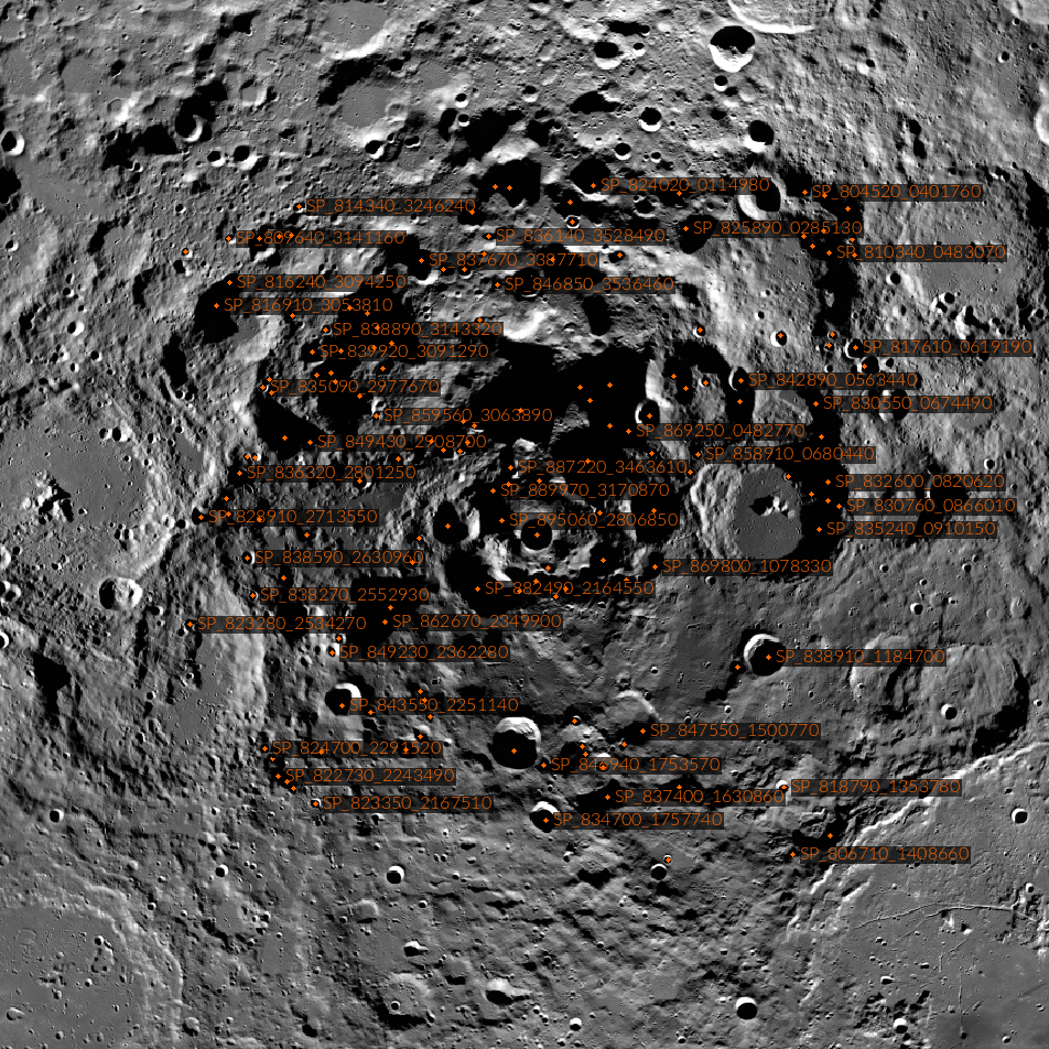
To make it easier to locate and use the long-exposure NAC images, the LROC team assembled an atlas of PSRs 10 km2 or larger that encompasses the regions within nine degrees of each pole (from 81 degrees north to 90 degrees north and from 81 degrees south to 90 degrees south).
For each PSR in the atlas, image mosaics and key supporting information about PSR location and size are provided. Available images and data vary, but may include:
- Percentage of the PSR covered by usable NAC images
- List of available NAC images
- A context image showing where the PSR is situated on a Lunar Orbiting Laser Altimeter (LOLA) topography colorshade map
- A mosaic of NAC images which offer the best available coverage of the PSR
- Up to seven mosaics showing the best day-of-year coverage
- A controlled mosaic of the PSR observations
You can explore the shadowlands here: http://lroc.sese.asu.edu/psr
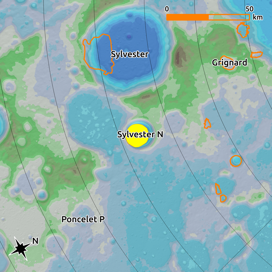
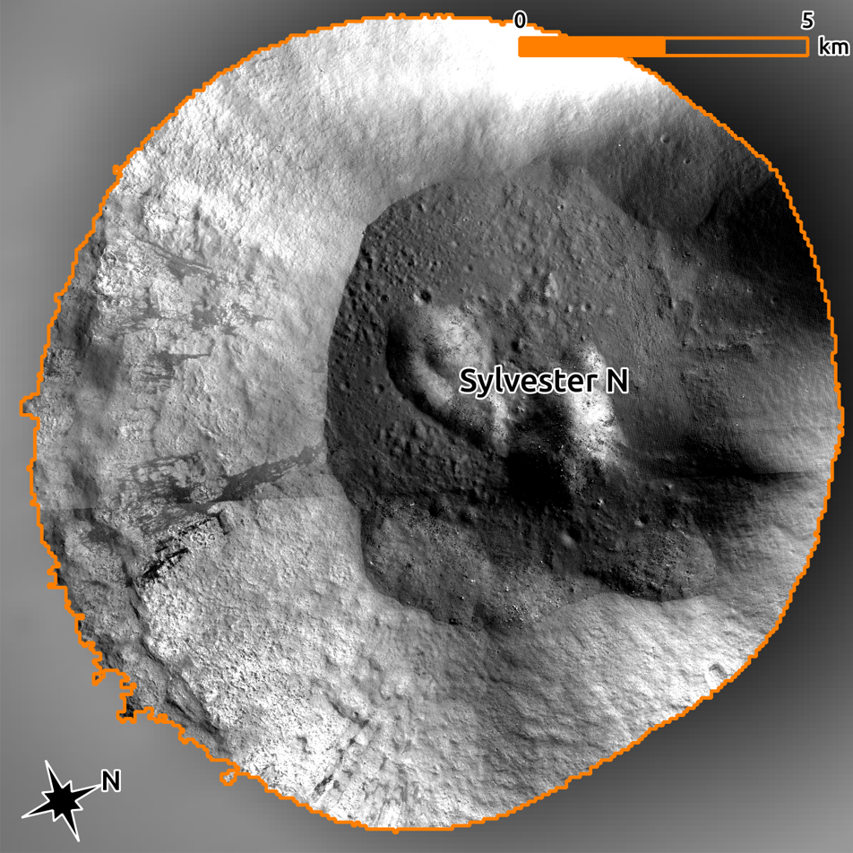
In addition to the PSR Atlas, the LROC team created and released several Reduced Data Records (RDRs) to the NASA-sponsored Planetary Data System (PDS). The RDRs include north and south pole mosaics made up of all the PSR images that offer the best coverage of the PSRs, as well as 16 controlled mosaics similar to the controlled mosaic below of the NP_823380_2913430 PSR in Sylvester N crater. Controlled mosaics are made from images tied together using a control network of commonly accepted points and adjusted to correct for spacecraft and camera pointing errors. This processing method results in seamless mosaics; the offsets between images that otherwise occur in mosaic images are eliminated.
For more information about PSRs, check out the introduction of the downloadable version of the PSR Atlas and these related posts:
Five Years Later: Revisiting an Old Friend
Eternal Darkness Near the North Pole
Polar Illumination Maps and More!
Searching for Ice at the Moon's Poles
Explore the full resolution Sylvester N controlled mosaic:
Explore the full resolution North Pole PSR Mosaic:
Explore the full resolution South Pole PSR Mosaic:
Published by Megan Henriksen on 27 January 2018