Pits Atlas: King 21
| Impact Melt pit: King | |
|---|---|
| Name | King 21 |
| Lat. | 6.517 |
| Long. | 119.9875 |
| Desc. | Triangular pit. The floor appears flat, and there appears to be a narrow (~1m wide) shelf halfway down the SE wall. There are several short fractures nearby, tracing a line from NW to SE, with closest approach of that line (albeit with no surface expression) ~60m SW. This pit is in flat ground, but the PRF containing King 31 is ~170m N. |
| Types | |
| Terrain | Impact Melt |
| Host Feature | King |
| Funnel Min. Diam. | 14 |
| Funnel Max. Diam. | 19 |
| Inner Min. Diam. | 9 |
| Inner Max. Diam. | 15 |
| Azimuth | 125 |
| Depth | 5.0 |
| Depth 1 | 6.3 |
| Depth 2 | 4.5 |
| Depth 3 | 5.5 |
| Best Stereo Left | M128509025R |
| Best Stereo Right | M128509025R |
| DTMs | NAC_DTM_KINGCRATER2 |
| Clipping Width | 200 |
| Other IMGs | |
| Data Warning | |
| Entrance Ramp | N |
| Overhang | ? |
| Nearby Pits? | Y |
| Nearby Fractures? | Y |
| Nearby Depressions? | Y |
| In Dome | N |
| Beside Dome | N |
| In Depression | N |
| Colinear Pits | N |
| Colinear Depressions | N |
| Colinear Fractures | Y |
| King 21 Shaded Relief | |
|---|---|
 |
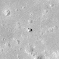
| M1120456952R | |
|---|---|
 |
|
| Line | 32326 |
| Sample | 2534 |
| Inc. Angle | 32.26 |
| Emission Angle | 1.21 |
| Time | 9.88 |
| Resolution | 1.17 |
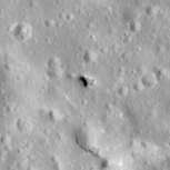
| M106088433R | |
|---|---|
 |
|
| Inc. Angle | -35.37 |
| Emission Angle | -2.07 |
| Time | 14.31 |
| Resolution | 1.29 |
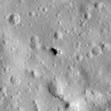
| M182745931R | |
|---|---|
 |
|
| Inc. Angle | -48.5 |
| Emission Angle | -1.07 |
| Time | 15.22 |
| Resolution | 1.27 |
| King 21 Stereo |
|---|
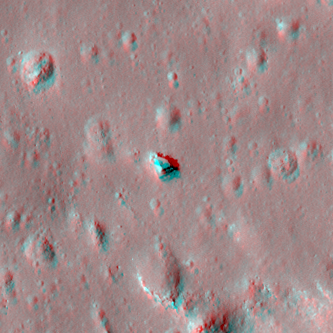 |