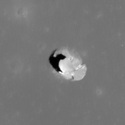
Pits Atlas: Schlüter Pit
| Highland pit: Schlüter Crater | |
|---|---|
| Name | Schlüter Pit |
| Lat. | -5.8395 |
| Long. | 276.95 |
| Desc. | Elliptical pit with extremely steep, crisp funnel. SW wall appears to be a continuous near-vertical slope that smoothly transitions into floor; NE wall is a knife-edge at the base of the funnel, with an overhang below. Funnel is 18 m deep. Pit is in Schlüter crater, ~4km from the edge of a mare patch. |
| Types | |
| Terrain | Highland |
| Host Feature | Schlüter Crater |
| Funnel Min. Diam. | 50 |
| Funnel Max. Diam. | 63 |
| Inner Min. Diam. | 23 |
| Inner Max. Diam. | 37 |
| Azimuth | 130 |
| Depth | 57.0 |
| Depth 1 | 58.2 |
| Depth 2 | 55.7 |
| Depth 3 | >51.0 |
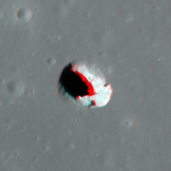
| Best Stereo Left | M1311225886R |
| Best Stereo Right | M1311225886R |
| DTMs | |
| Clipping Width | 200 |
| Other IMGs | |
| Data Warning | Depths 1 and 2 appear to be on flat floor based on shadow shape. Listed stereo pair is accidental, but good for manual viewing, intentional stereo pair of the site is M1106460355R/M1106474650R. |
| Entrance Ramp | N |
| Overhang | Y |
| Nearby Pits? | N |
| Nearby Fractures? | N |
| Nearby Depressions? | N |
| In Dome | N |
| Beside Dome | N |
| In Depression | N |
| Colinear Pits | N |
| Colinear Depressions | N |
| Colinear Fractures | N |
| Schlüter Pit Shaded Relief | |
|---|---|
 |
| M1328836141R | |
|---|---|
 |
|
| Line | 22300 |
| Sample | 1168 |
| Inc. Angle | -11.93 |
| Emission Angle | -0.38 |
| Time | 12.65 |
| Resolution | 0.94 |
| M1313570429R | |
|---|---|
 |
|
| Inc. Angle | -14.09 |
| Emission Angle | 0.17 |
| Time | 12.89 |
| Resolution | 0.76 |
| M1315920479R | |
|---|---|
 |
|
| Inc. Angle | 15.29 |
| Emission Angle | 0.56 |
| Time | 11.04 |
| Resolution | 0.76 |
| Schlüter Pit Stereo |
|---|
 |