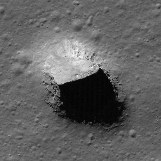
Pits Atlas: Compton Pit
| Mare pit: Compton Crater | |
|---|---|
| Name | Compton Pit |
| Lat. | 56.2247 |
| Long. | 106.1955 |
| Desc. | Elliptical pit, with extremely similar shape to the Mare Ingenii pit. NW side is a slope from surface to permanent shadow. Numerous layers visible on W wall in nadir images, similar to S wall of Lacus Mortis. There is an overhang under the E rim at the edge of the permanent shadow. No notable features within a few km, though the W edge of the unit the pit is in, ~10 km away, has a weird, scalloped edge. |
| Types | |
| Terrain | Mare |
| Host Feature | Compton Crater |
| Funnel Min. Diam. | 140 |
| Funnel Max. Diam. | 230 |
| Inner Min. Diam. | 92 |
| Inner Max. Diam. | 110 |
| Azimuth | 140 |
| Depth | 35.0 |
| Depth 1 | 26.6 |
| Depth 2 | 38.7 |
| Depth 3 | 40.0 |
| Best Stereo Left | M1225299477R |
| Best Stereo Right | M1225299477R |
| DTMs | |
| Clipping Width | 300 |
| Other IMGs | |
| Data Warning | Inner max diam is from permanently-shadowed SE rim to NW-most bit of rim by NW slope. Depths are from partway down funnel, not from inner rim, and go to partway down slope. |
| Entrance Ramp | Y |
| Overhang | ? |
| Nearby Pits? | N |
| Nearby Fractures? | N |
| Nearby Depressions? | N |
| In Dome | N |
| Beside Dome | N |
| In Depression | N |
| Colinear Pits | N |
| Colinear Depressions | N |
| Colinear Fractures | N |
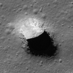
| Compton Pit Shaded Relief | |
|---|---|
 |
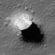
| M110892182R | |
|---|---|
 |
|
| Line | 44678 |
| Sample | 1988 |
| Inc. Angle | 60.26 |
| Emission Angle | 0.84 |
| Time | 10.59 |
| Resolution | 0.58 |
| M1332351545L | |
|---|---|
 |
|
| Inc. Angle | 60.01 |
| Emission Angle | -1.02 |
| Time | 10.27 |
| Resolution | 1.2 |
| M189923763R | |
|---|---|
 |
|
| Inc. Angle | 61.63 |
| Emission Angle | 1.02 |
| Time | 9.76 |
| Resolution | 1.83 |
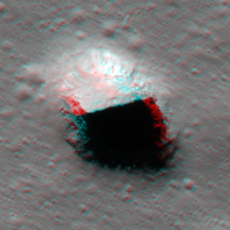
| Compton Pit Stereo |
|---|
 |